Showing 100 items matching camp accommodation
-
 Tatura Irrigation & Wartime Camps Museum
Photograph
... Internment camp accommodation... Tatura Internment camps Internment camp accommodation ...Camp 13 Tatura during WW2.Black and white photo of camp tents and huts surrounded by perimeter fences containing rolled barbed wire. Men in foreground.camp 13 tatura, internment camps, internment camp accommodation -
 Tatura Irrigation & Wartime Camps Museum
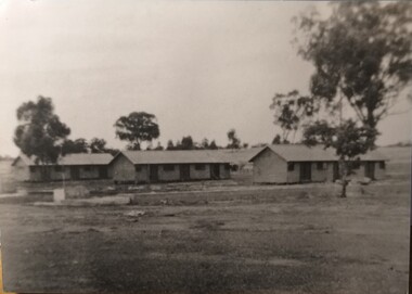
Photograph, Camp 3 1941
... Camp accommodation.... Historic Camp 3 Camp huts Camp accommodation Manfred Haering ...3 of the camp huts in 1941 just after the camp opened to internees.HistoricBlack and white photograph of 3 huts with trees in back ground and 2 trees in middle of picture. Washing on line behind middle hut.camp 3, camp huts, camp accommodation, manfred haering -
 Tatura Irrigation & Wartime Camps Museum
Photograph, POW Camp 13 - Tents
... Internment camp accommodation... tents Internment camp accommodation ...Painted by Klober at Camp 13.Photograph of watercolour depicting tents, army huts and 11 gum trees.Klober ? 41klober, gus pohlig, camp 13 art, watercolour paintings, pow camp 13, internment camp tents, internment camp accommodation -
 National Wool Museum
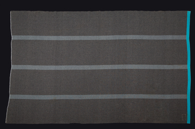
Blanket, 1942
... . It was provided for camping and accommodation by the BHC..... It was provided for camping and accommodation by the BHC. Eagley / MILLS ...Made in 1942, this blanket has spent 60 years in the Belgrave Heights Convention Centre in the Dandenongs. It was provided for camping and accommodation by the BHC.Grey woolen blanket with 3 blue stripes. Large stain. Eagley Mills 1942 label in bottom right corner. Blue edging along the two short sides.Eagley / MILLS / 1942 -
Tatura Irrigation & Wartime Camps Museum
Photograph, Camp 13 Garrison
... Camp 13 Garrison Accommodation.|Recreation Hall later...Tatura Irrigation & Wartime Camps Museum 49 Hogan Street ...Camp 13 Garrison Accommodation.|Recreation Hall later removed to Murchison.|5 Photos.photograph, people -
 Falls Creek Historical Society
Photograph - Rocky Valley Camp
... A black and white image of Rocky Valley Camp. Work began... Snowfields A black and white image of Rocky Valley Camp. Work began ...MEYER COLLECTION - FALLS CREEK PHOTOS In 1947 a determined group of like-minded State Electricity Commission (SEC) staff including Ray Meyer, the chief surveyor of the Kiewa Hydro-Electric Scheme, had a common interest that revolved around the skiing potential of the snow-covered high plains which included what is now the resort of Falls Creek. The six SEC employees, Toni St Elmo, Ray Meyer, Jack Minogue, Lloyd Dunn, Adrian Ruffenacht and Dave Gibson (together with their families) banded together to secretly build a 'hut' that was the first ski lodge at Falls Creek. Using a road built in 1930s to gain access to Falls Creek, their hut project was carried out in secret as efforts by other skiers were blocked by H.H.C. Williams – the engineer in charge of the Hydro Scheme. In 1946 Ray Meyer made a trip to the Lands Office in Melbourne. He came away with a 99-year lease on three acres that was ideally suited for a hut designed by Lloyd Dunn. Adrian Ruffenacht (Design Engineer for the KHS) had suggested where the group should build because of easy access to a spring for water. Much of the building material required was scavenged from derelict huts on the high plains. Due to the need for secrecy, the determined group worked on the hut in the evenings and weekends to avoid detection. During the building period the group had met at Echidna Rock (now known as Eagle Rock) where Skippy St Elmo announced, "This is my favourite ‘Skyline’.” And so the first lodge in the area at Falls Creek Ski Resort came into existence. With the development of the International Poma in the 1970s, the Skyline Lodge, which was sited between the ski-lift’s pole one and pole two, was demolished. However, the legacy of Ray Meyer, Toni St Elmo, Jack Minogue, Lloyd Dunn, Adrian Ruffenacht and Dave Gibson and Skyline lives on in the vibrant atmosphere of Falls Creek Resort. The MEYER COLLECTION documents developments on the Kiewa Hydro Scheme and their life at Falls Creek from the mid 1930s to 1960s.This image is significant because it documents the development of the Kiewa Hydroelectric Scheme.A black and white image of Rocky Valley Camp. Work began on the Rocky Valley Dam site in early 1947 and continued until May. It resumed in October after the winter and a camp for the accommodation of workmen was commenced at this time. Work continued in 1948 with the establishment of work facilities, including the erection of two large excavators. The Rocky Valley Dam was completed in 1959.ray meyer, blairs hut, falls creek, victorian snowfields -
 Falls Creek Historical Society
Photograph - Rocky Valley Camp, c1949
... A black and white image of Rocky Valley Camp. Work began... Hydroelectric Scheme. Falls Creek Victorian Snowfields Rocky Valley Camp ...MEYER COLLECTION - FALLS CREEK PHOTOS In 1947 a determined group of like-minded State Electricity Commission (SEC) staff including Ray Meyer, the chief surveyor of the Kiewa Hydro-Electric Scheme, had a common interest that revolved around the skiing potential of the snow-covered high plains which included what is now the resort of Falls Creek. The six SEC employees, Toni St Elmo, Ray Meyer, Jack Minogue, Lloyd Dunn, Adrian Ruffenacht and Dave Gibson (together with their families) banded together to secretly build a 'hut' that was the first ski lodge at Falls Creek. Using a road built in 1930s to gain access to Falls Creek, their hut project was carried out in secret as efforts by other skiers were blocked by H.H.C. Williams – the engineer in charge of the Hydro Scheme. In 1946 Ray Meyer made a trip to the Lands Office in Melbourne. He came away with a 99-year lease on three acres that was ideally suited for a hut designed by Lloyd Dunn. Adrian Ruffenacht (Design Engineer for the KHS) had suggested where the group should build because of easy access to a spring for water. Much of the building material required was scavenged from derelict huts on the high plains. Due to the need for secrecy, the determined group worked on the hut in the evenings and weekends to avoid detection. During the building period the group had met at Echidna Rock (now known as Eagle Rock) where Skippy St Elmo announced, "This is my favourite ‘Skyline’.” And so the first lodge in the area at Falls Creek Ski Resort came into existence. With the development of the International Poma in the 1970s, the Skyline Lodge, which was sited between the ski-lift’s pole one and pole two, was demolished. However, the legacy of Ray Meyer, Toni St Elmo, Jack Minogue, Lloyd Dunn, Adrian Ruffenacht and Dave Gibson and Skyline lives on in the vibrant atmosphere of Falls Creek Resort. The MEYER COLLECTION documents developments on the Kiewa Hydro Scheme and their life at Falls Creek from the mid 1930s to 1960s.This image is significant because it depicts aspects of the development of the Kiewa Hydroelectric Scheme.A black and white image of Rocky Valley Camp. Work began on the Rocky Valley Dam site in early 1947 and continued until May. It resumed in October after the winter and a camp for the accommodation of workmen was commenced at this time. Work continued in 1948 with the establishment of work facilities, including the erection of two large excavators. The Rocky Valley Dam was completed in 1959.falls creek, victorian snowfields, rocky valley camp -
 Kiewa Valley Historical Society
Photograph Rocky Valley Dam Excavations, Rocky Valley Dam Wall Excavation, c1947-48
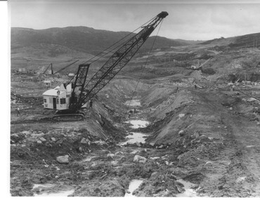
... and a camp for the accommodation of workmen was commenced... work in October after the winter and a camp ...Work commenced at Rocky Valley Dam site in early 1947 and proceeded until May. Resumed work in October after the winter and a camp for the accommodation of workmen was commenced at this time. Work continued in 1948 with the establishment of work facilities, including the erection of two large excavators. At the dam site the river was diverted through a temporary pipeline. Work proceeded in the summer months with the placing of concrete in the foundations and earth and rock fill for the construction of the wall. Rocky Valley and associated spillway and outlet works were completed in March, 1959. A very good representation of the type of machinery available in the 1940's used for excavation of the dam and the construction of the dam wall.Black and white photograph of Rocky Valley Dam wall under construction. There are at least three cranes plus workmen in the photo. This is taken from the Heathey's Spur side of the dam wall looking back toward Sun Valley.Hand written on back of photograph "Rocky Valley Dam Wall Excavation" in blue ink.rocky valley, dam, wall, machinery -
 Kiewa Valley Historical Society
Black and white photograph of Surveyor's Camp, 1938, Kiewa River and surveyor's Camp 25/8/38, 25/08/1938
... and access was by bridle tracks, on foot or horseback. This camp... is the inscription "Kiewa River and Surveyor's Camp 25/8/38". The number 4 ...Surveying under the prevailing conditions at this time was an arduous and demanding task. There were no roads beyond Tawonga and access was by bridle tracks, on foot or horseback. This camp was to provide accommodation to those men who were surveying the road from South Tawonga to the Bogong High Plains which was commenced in April, 1938. The actual work was undertaken by the Country Roads Board, on behalf of the State Electricity Commission, using three Caterpillar diesel crawler tractors equipped with Kay Bruneriei (Brunner) lhydraulically operated trailbuilders (angle dozers)This photograph shows the primitive living conditions that were endured by those carrying out the initial field investigations and surveys for the Kiewa Hydro Electric Scheme. It is possibly one of the few photographs in existence of this camp and of the very rustic timber foot bridge across the West Kiewa river. It has been taken from approx. 100m up Simmonds Creek Road. A black and white photograph showing a small, timber foot bridge across the West Kiewa River. There is a man standing on the bridge and two small huts on the far side of the river, against a backdrop of Mt. Beauty and Mt. Bogong.At the top of the photograph, handwritten in black ink is the inscription "Kiewa River and Surveyor's Camp 25/8/38". The number 4 is stamped towards the right upper corner. On the back, in a circle, about 1.3cm in diameter, are the words "Kodak Print". The word "Velox" is faintly discernible on the back as well.surveyor, tawonga, west kiewa river, bridge, camp, secv -
 Melbourne Legacy
Document, The training of new Legatees. 26 May 1954 (H20), 1954
... and Employment Committee 4) Residences, Housing and Accommodation, Camp..., Housing and Accommodation, Camp and Holidays Committees. 5 ...In the report on the work of Legacy in 1953 (see item 01491) it was mentioned that the education of Legatees was seen as something that needed to be addressed and a formal induction process with proper training would be necessary. A two page report was included as attachment 'C'. This is the report. It mentions the Board of Management decided to inaugurate a course of classes, over six Monday evenings. The topics covered: 1) The structure of Legacy and the nature of contact work. 2) Welfare Committee and Welfare assistance available from statutory sources. 3) Education and Employment Committee 4) Residences, Housing and Accommodation, Camp and Holidays Committees. 5) The Medical, Dental, Boys' and Girls' Group Committees. 6) Personnel and Comradeship. The notation H20 in red pen shows that it was part of the archive project that was trying to capture the history of Legacy. A report covering the need to train Legatees and how it was proposed to be achieved by a course of lectures.White foolscap paper with black type x 2 pages of recommendations of training of new Legatees.Handwritten H20 in red pen. Handwritten 'C' in top right corner.history, organisation structure, rules -
 Falls Creek Historical Society
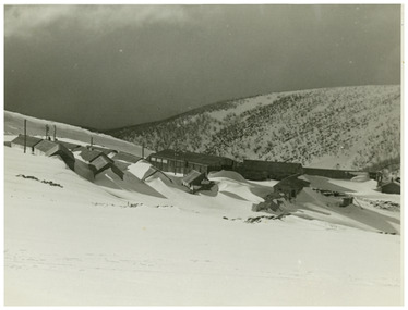
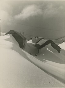
Photograph - Building Rocky Valley Dam Wall
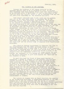
... . It resumed in October after the winter and a camp.... It resumed in October after the winter and a camp ...The Rocky Valley Dam is located on the Bogong High Plains, near Falls Creek, Victoria. The dam is man-made and has a capacity of 28,000 megalitres (990×106 cu ft). At an elevation of 1600m, Rocky Valley Dam is the highest significant body of water in Australia. The dam was created for the Kiewa Hydroelectric Scheme. Just a short distance from the heart of the village, the lake provides a playground for a range of aquatic activities. It is also utilised in snow making for the Falls Creek ski resort. Work began on the Rocky Valley Dam site in early 1947 and continued until May. It resumed in October after the winter and a camp for the accommodation of workmen was commenced at this time. Work continued in 1948 with the establishment of work facilities, including the erection of two large excavators. The Rocky Valley Dam was completed in 1959.These images are significant as they capture work carried out to build the wall at Rocky Valley near Falls Creek, VictoriaThree black and white images showing work on the Rocky Valley Dam, Victoriarocky valley dam, kiewa hydroelectric scheme, falls creek -
 Bendigo Historical Society Inc.
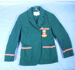
Textile - High School Blazer
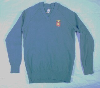
... , was established in temporary accommodation at Camp Hill Primary School..., was established in temporary accommodation at Camp Hill Primary School ...Golden Square High School in the city of Bendigo, was established in temporary accommodation at Camp Hill Primary School in central Bendigo in 1960. With the completion of the new school's buildings, it moved to Golden Square in 1962, providing for Forms 1 to 6, now known as years 7 to 12. In 1978 it became a 7–10 school and was one of the original feeder schools to Bendigo Senior High School. In 1986, a Hearing Impaired Unit was established and in 1990 it underwent a name change to become Golden Square Secondary College. The Golden Square Secondary College campus closed on 28 November 2008. It merged with Kangaroo Flat and Flora Hill secondary colleges as part of the implementation of the Bendigo Education Plan. Its buildings were demolished. (Wikipedia https://en.wikipedia.org/wiki/Golden_Square_Secondary_College)Golden Square High School Blazer. The green blazer has one upper and two lower pockets, each lined at the top with a strip of gold fabric with diagonal red stripes and a row of red stitching bordering the strip. The top pocket shows the school emblem i colours of green, gold, red and white in square and rectangular block formation. "High School" is written in gold against a white background at the top of the emblem and "Golden Square" is embroidered in part circle below the emblem. The name is dark gold against a fainter gold background. The Blazer is fastened with three buttons. Only one button remains attached. Another button is in a pocket. A label under the collar reads "Tailored by Clark in Pure wool' "Size 34". Two badges are pinned to the top pocket. "PREFECT" . Reflecting the school colours - gold lettering on red on a green rectangle set against a gold oval shape. "S.R.C." Gold lettering on green background.Written on the label "K Jeffrey 7G". Also written in pen on the lining inside of the upper arm. There is also another crossed out name.gssc, school uniform -
 Bendigo Historical Society Inc.
Textile - High School jumper
... , was established in temporary accommodation at Camp Hill Primary School..., was established in temporary accommodation at Camp Hill Primary School ...Golden Square High School in the city of Bendigo, was established in temporary accommodation at Camp Hill Primary School in central Bendigo in 1960. With the completion of the new school's buildings, it moved to Golden Square in 1962, providing for Forms 1 to 6, now known as years 7 to 12. In 1978 it became a 7–10 school and was one of the original feeder schools to Bendigo Senior High School. In 1986, a Hearing Impaired Unit was established and in 1990 it underwent a name change to become Golden Square Secondary College. The Golden Square Secondary College campus closed on 28 November 2008. It merged with Kangaroo Flat and Flora Hill secondary colleges as part of the implementation of the Bendigo Education Plan. Its buildings were demolished. (Wikipedia https://en.wikipedia.org/wiki/Golden_Square_Secondary_College)Navy jumper. School emblem embroidered with "GOLDEN SQUARE" in navy and black placed above squares / shapes in a maze like pattern. A label on the back "DUX" "Made by Dobson's" Size 16. Reverse of label details washing instructions and identifies composition 80% wool and 20% nylon. gssc, school uniform -
 Bendigo Historical Society Inc.
Textile - High School windcheater
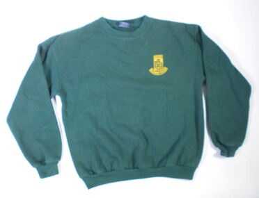
... , was established in temporary accommodation at Camp Hill Primary School..., was established in temporary accommodation at Camp Hill Primary School ...Golden Square High School in the city of Bendigo, was established in temporary accommodation at Camp Hill Primary School in central Bendigo in 1960. With the completion of the new school's buildings, it moved to Golden Square in 1962, providing for Forms 1 to 6, now known as years 7 to 12. In 1978 it became a 7–10 school and was one of the original feeder schools to Bendigo Senior High School. In 1986, a Hearing Impaired Unit was established and in 1990 it underwent a name change to become Golden Square Secondary College. The Golden Square Secondary College campus closed on 28 November 2008. It merged with Kangaroo Flat and Flora Hill secondary colleges as part of the implementation of the Bendigo Education Plan. Its buildings were demolished. (Wikipedia https://en.wikipedia.org/wiki/Golden_Square_Secondary_College)Dark green windcheater with school emblem. Embroidered in gold. "Golden Square Secondary College". Brand label on the back "OZ Surf. Made in China.. Size Small." Washing instructions included.gssc, school uniform, gshs -
 Bendigo Historical Society Inc.
Award - School Sport Shields
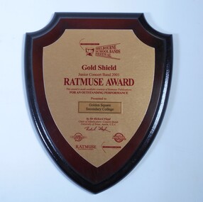
... , was established in temporary accommodation at Camp Hill Primary School..., was established in temporary accommodation at Camp Hill Primary School ...Golden Square High School in the city of Bendigo, was established in temporary accommodation at Camp Hill Primary School in central Bendigo in 1960. With the completion of the new school's buildings, it moved to Golden Square in 1962, providing for Forms 1 to 6, now known as years 7 to 12. In 1978 it became a 7–10 school and was one of the original feeder schools to Bendigo Senior High School. In 1986, a Hearing Impaired Unit was established and in 1990 it underwent a name change to become Golden Square Secondary College. The Golden Square Secondary College campus closed on 28 November 2008. It merged with Kangaroo Flat and Flora Hill secondary colleges as part of the implementation of the Bendigo Education Plan. Its buildings were demolished. (Wikipedia https://en.wikipedia.org/wiki/Golden_Square_Secondary_College)Two wooden shields awarded to Golden Square Secondary College at the Melbourne School Bands Festival. Dark wood in the shape of a shield. a. Gold Shield awarded to the Junior Concert Band in 2001. TATMUSE AWARD for Outstanding Performance. Presented by Mr Richard Floyd. Sponsors represented by logos - Music Junction, Billy Hyde, RATMUSE (Music Publishers). Education Trust Vic. b. Yamaha Gold Award won by Golden Square Secondary College Intermediate Concert band 2003 at the Melbourne School Bands Festival. Presented to Symphonic Winds by Mr. K Waterworth. Award sponsored by Yamaha Music Australia, Billy Hyde Music. Blue border around a gold coloured shield.a. Sticker on the back of the Shield. "WINNING EDGE PRESENTATIONS Wholesale Trophy Framing and Giftware level 9 230 Collins Street Melbourne phone 9654 4911 Fax 9650 7106"gssc, sports top, music awards -
 Bendigo Historical Society Inc.
Textile - School Banner
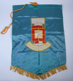
... , was established in temporary accommodation at Camp Hill Primary School..., was established in temporary accommodation at Camp Hill Primary School ...Golden Square High School in the city of Bendigo, was established in temporary accommodation at Camp Hill Primary School in central Bendigo in 1960. With the completion of the new school's buildings, it moved to Golden Square in 1962, providing for Forms 1 to 6, now known as years 7 to 12. In 1978 it became a 7–10 school and was one of the original feeder schools to Bendigo Senior High School. In 1986, a Hearing Impaired Unit was established and in 1990 it underwent a name change to become Golden Square Secondary College. The Golden Square Secondary College campus closed on 28 November 2008. It merged with Kangaroo Flat and Flora Hill secondary colleges as part of the implementation of the Bendigo Education Plan. Its buildings were demolished. (Wikipedia https://en.wikipedia.org/wiki/Golden_Square_Secondary_College)Golden Square High School banner. A large green banner made of silk like material. The lower edge of the banner is fringed with gold coloured cord. A thick gold coloured hanging cord is attached to the top.gssc, sports top -
 Bendigo Historical Society Inc.
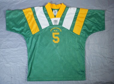
Textile - GSSC Sports top
... , was established in temporary accommodation at Camp Hill Primary School..., was established in temporary accommodation at Camp Hill Primary School ...Golden Square High School in the city of Bendigo, was established in temporary accommodation at Camp Hill Primary School in central Bendigo in 1960. With the completion of the new school's buildings, it moved to Golden Square in 1962, providing for Forms 1 to 6, now known as years 7 to 12. In 1978 it became a 7–10 school and was one of the original feeder schools to Bendigo Senior High School. In 1986, a Hearing Impaired Unit was established and in 1990 it underwent a name change to become Golden Square Secondary College. The Golden Square Secondary College campus closed on 28 November 2008. It merged with Kangaroo Flat and Flora Hill secondary colleges as part of the implementation of the Bendigo Education Plan. Its buildings were demolished. (Wikipedia https://en.wikipedia.org/wiki/Golden_Square_Secondary_College)Dark green short sleeved synthetic sports top with gold coloured V shaped collar. There are gold and white diagonal stripes on the collar. Symbol on the front of a soccer ball and decorative wreath with letters "SSI" and "Golden Square S C" The number % is in large print on the front and back. Made in Thailand.gssc, sports top -
 The Beechworth Burke Museum
Photograph
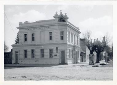
The old Bank of New South Wales building is located on the corner of Camp and Ford streets in Beechworth, Victoria. It was constructed between 1856 and 1857 from local honey coloured granite. It was designed by architects Robertson & Hale and is a two-storey rendered brick building and the original coat of arms is still visible. The coat of arms is distinctive and consists of a kangaroo, emu, lion, and rising sun. The rear of the building was surrounded by high granite walls for security as it was the original home for the local gold office. Beechworth Honey currently offers tourist accommodation in the Hive Apartment located in the former Bank of New South Wales Managers residence.The Bank of New South Wales building in Beechworth is significant for its location in one of Australia's most prominent goldfield towns. Of particular interest is the use of distinctive local Beechworth honey coloured granite in its construction. The building’s architecture is a simple, conservative classical style known as Renaissance Revival. It is one of the few known surviving works of the architects Robertson and Hale. The decorative composition above the main entrance and the counter in the banking chamber are of special interest.Black and white rectangular photograph printed on cardAHold bank of new south wales, bank of new south wales building, beechworth bank of new south wales, bank of nsw, beechworth 1850s, robertson and hale, architects robertson and hale, rendered brick, coat of arms, granite walls, local honey coloured granite, gold office, 1856, 1857, beechworth, beechworth honey, hive apartment, manager's residence, renaissance revival -
 Kiewa Valley Historical Society
Photograph from Lake Guy, Bogong Village, Scene from shores of Lake Guy to Mountain range, 1930s to 1950s
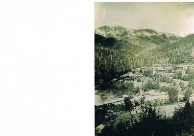
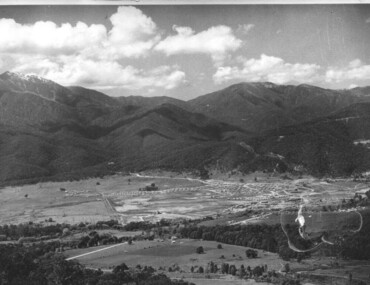
... was developed firstly as an accommodation centre (base camp ...In 1940 Field Headquarters for the Kiewa Scheme were established at Bogong with office, workshop facilities and accommodation for workmen, staff and some families constructed. (There had been a 'tent camp' on this site in 1939 but was destroyed by bushfires) Construction of accommodation continued until 1947. A total of 40 houses plus a hostel for single staff, post office, police station, medical centre and primary school all with water and sewerage and electricity supply. The staff hostel was known as Kiewa House and is now occupied by the Education Department. Lake Guy was named after Mr. L.T. Guy who was the Resident Engineer in charge of construction work and associated activities on the Kiewa area. He held this position from 1939 to November 1946 when he was transferred to Head Office.The Bogong Township was developed firstly as an accommodation centre (base camp) for construction workers employed under the Kiewa Hydroelectric Scheme. Due to the influx of European workers into the Township the beautification of the immediate surrounds(gardens etc.) had a distinct European flavour. This environment has been very beneficial for tourism in later years. Strict environmental control has not allowed for any extensive redevelopment in tourist accommodation and basically restricted it to the accommodation initially built for the construction workers. Activities such a bike riding, snow skiing, restricted horse riding and bush walking on the Alpine plains and mountains are now a viable part of the Kiewa Valley Tourist Industry. The lake is one of the many water storage storage reservoirs used to supply the power stations their main power to run the huge turbines generating the final product, electricityThis black and white photograph shot from the shores of Lake Guy toward the mountain range of the Victorian Alps details the early construction of the construction worker's accommodation of the Bogong Village. The paper is of 200gms and is not photographic paper and can be assumed to be a reproduction of an original photobogong village circa 1930 to 1950, kiewa hydro-electricity scheme, victorian alpine region mid 1900s -
 Kiewa Valley Historical Society
Photograph Bogong Township, Bogong Township Circa 1940s right side view, circa 1950
... camp for construction workers under the Kiewa Hydroelectric ...The Bogong Township (circa 1930s) was constructed by The State Electricity Commission of Victoria as a base camp for construction workers under the Kiewa Hydroelectric Scheme starting in 1938. The Scheme employed 4000 men during its construction phase. A small number were first housed at Bogong Village and when required the Mount Beauty Township was established(1949). Construction at the dams and Power Stations was interrupted during World War II. June 1951 started construction at full pace. The Bogong Township was developed firstly as an accommodation centre (base camp) for construction workers employed under the Kiewa Hydroelectric Scheme. Due to the influx of European workers into the Township the beautification of the immediate surrounds(gardens etc.) had a distinct European flavour. This environment has been very beneficial for tourism in later years. Strict environmental control has not allowed for any extensive redevelopment in tourist accommodation and basically restricted it to the accommodation initially built for the construction workers. Activities such a bike riding, snow skiing, restricted horse riding and bush walking on the Alpine plains and mountains are now a viable part of the Kiewa Valley Tourist Industry.Scanned copy of original black and white photo. Paper manufacturer is Kodak. Paper is Kodak XtraLife II.On reverse side "Kodak ExtaLife II paper"bogong village, bogong township, sec alpine constructions, victorian alpine tourism, winter sports. -
 Kiewa Valley Historical Society
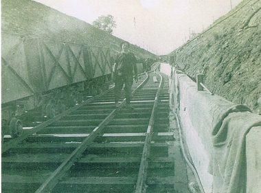
Photograph KHS Rail, Kiewa Hydroelectric Scheme Railway, Circa1940s
... construction workers located in two main accommodation camps, Mount ...This photograph shows part of the railway constructed and used for the removal of soil and rocks from the tunnels bored out of the mountains for the pipeline servicing the Hydro Electricity power stations in the Kiewa Hydroelectric Scheme. This photo details an era when there were 4,000 construction workers located in two main accommodation camps, Mount Beauty (the larger one) and Bogong village. These accommodation sites were constructed and maintained as a secured or gated residential area with access only available by a special pass authorised by the Kiewa Hydroelectric Scheme. All the power used by the rail system was from electric motors connected to batteries. Overhead power poles seen on either side of the embankment details that electricity from the Scheme was in use. This use was cleaner and more environmentally friendly than the coal still used by large locomotives from city to country railways. The worker shown is not however wearing protective head and hand coverings. This is also an era where there was a lack of health and safety legislation covering workers in dangerous working conditions.Scanned photo of original black and white photo on Kodak XtraLife II paper. Picture is of a section of railway track servicing the tunnels of the Hydroelectric scheme during the 1940s - 1950sOn back of photo "Kodak XtraLife II paper"railway in kiewa electric scheme, tunneling -
 Kiewa Valley Historical Society
Photograph of Lake Guy and Bogong Village, Lake Guy and Bogong Village, Approx. 1945
In 1940 Field Headquarters for the Kiewa Scheme were established at Bogong with office, workshop facilities and accommodation for workmen, staff and some families constructed. (There had been a 'tent camp' on this site in 1939 but was destroyed by bushfires) Construction of accommodation continued until 1947. A total of 40 houses plus a hostel for single staff, post office, police station, medical centre and primary school all with water and sewerage and electricity supply. The staff hostel was known as Kiewa House and is now occupied by the Education Department. Lake Guy was named after Mr. L.T. Guy who was the Resident Engineer in charge of construction work and associated activities on the Kiewa area. He held this position from 1939 to November 1946 when he was transferred to Head Office.This photograph is an excellent historical record of Bogong Village in about 1945. It shows the layout of the town in the fairly steep terrain, the workmen's camp between the houses and the lake foreshore, the Commissioner's Lodge on the hill behind the Village, the walkway through the dam wall can be seen to the left of the spillway, the dam is on spill and note damage to the large trees is still evident from the 1939 bush fires. The Commissioner's Lodge was lost in the 2003 fires and the camp buildings were in service until 1962, when they were removed and the site converted into a public picnic area with lawns and gardens.A Black and white photograph"Lake Guy and Bogong" hand written on back of photograph.kiewa, accommodation, lake, dam, bogong -
 Kiewa Valley Historical Society
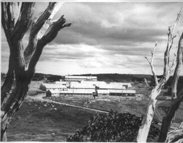
Photograph of Mt. Beauty, Mt. Beauty from transmission line, Approx 1950/51
This photo is of the very newly constructed State Electricity Commission town of Mt. Beauty. The houses up to Nelse street were erected from 1946 onward and then the township was extended beyond Nelse Street in 1950 which places this photograph about 1950/51. There is no evidence of work being commenced on the regulating pondage but the tail race canal can be seen on the centre right of photo. The workmen's camp was enlarged in 1950 to the extent of providing accommodation for a total of 1,200. There are a number of dwellings on Simmonds Creek and the road to Falls Creek can clearly be seen. Snow capped Mt. Bogong is in the upper left of the photo with Mt. Beauty behind the township rising to Big Hill beyond that.Shows the newly constructed town of Mt. Beauty surrounded by farmland and before the regulating pondage was built to discharge water from the power stations via the West Kiewa tail race tunnel into the Kiewa River. Black and white photographHand written on back of photograph "Mt. Beauty from Transmission Line"mt. beauty, construction, pondage, state electricity commission -
 Kiewa Valley Historical Society
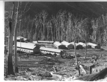
Photograph of Howmans Dam Camp, Howmans Dam Camp, circa 1948
... of the type of buildings and size of the camp for accommodation ...Howman's Gap camp was erected in 1948. The proposed dam to be built at this site was postponed in 1954 because of financial restraints imposed by the government at this time. It was to have supplied water for No. 2 Power Station at the Junction of the Pretty Valley and Rocky Valley branches of the East Kiewa River. This power station was not constructed until 2008 - 2010 and now gets it water from McKay Creek Power Station. The site of this camp is now occupied by the Howman's Gap Alpine Centre. Some of the original buildings still remain. An excellent photographic record of the type of buildings and size of the camp for accommodation of workmen during construction of the Kiewa Hydro Electric Scheme.Black and white photograph of the buildings erected at Howmans Dam site as accommodation for workmen.Handwritten in blue ink on the back of photograph "Howmans Dam Camp"howman's gap, camp, water, dam -
 Kiewa Valley Historical Society
Photograph of Pretty Valley Camp, Pretty Valley Camp, circa 1948
At the Pretty Valley Dam site erection of staff quarters was completed in April, 1947 and accommodation for workmen commenced in 1948 but suspended on 11th May for winter and resumed on 9th November. Construction of this camp was completed in 1949. A large dam was proposed at this site but was never constructed. Instead a small diversion dam was built which diverts water either to Rocky Valley Dam or to McKay Creek Power Station.An historical record of the type of accommodation provided for workmen during the construction of the Kiewa Hydro Scheme during the 1940's/50'sBlack and white photograph of Pretty Valley Camp showing general terrain and the huts built to accommodate workmen employed on the Kiewa Hydro Electric Scheme.pretty valley, dam, water, workmen, camp -
 Kiewa Valley Historical Society
Photograph of Pretty Valley Workers Camp*, Pretty Valley Camp, circa 1949
Erection of staff quarters at Pretty Valley was completed in April, 1947 and accommodation for construction workers commenced in 1948 but suspended on 11th May for winter and resumed on 9th November. Construction of this camp was completed in 1949. A large dam was proposed at this site but was never constructed. Instead a small diversion dam was built which diverts water either to Rocky Valley Dam or to McKay Creek Power Station.An historical record of the type of accommodation provided for workmen during the construction of the Kiewa Hydro Scheme during the 1940's/50's.A black and white photograph of Pretty Valley Camp, c 1949. Dead trees are in the foreground, on both the left and right side of the photograph and a small snow gum is evident. There are camp huts and a much larger building behind these, possibly a workshop, and power poles are evident bringing electricity to the site.Handwritten in blue ink on back of photograph "Pretty Valley Camp. 5600 ft. above sea level".pretty valley, dam, water, workmen, camp -
 Kiewa Valley Historical Society
Pot Large with Tap, Circa 1950
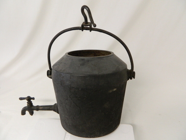
This type of cast iron kettle was used by pioneer families, mainly rural in the early 1900's upon open fires (log). It covered rural activities that needed a constant readily available source of boiling water, in or mainly outside the kitchen of homesteads. This kettle was used in the early to late 1900's for the refreshment of stock men and farmers that had irregular "tea" breaks under sometimes hard and gruelling conditions.This kettle belonged to and was used by a Kiewa Valley, pioneer family, the Roper Family. This kettle was moved from their Kiewa Valley property to their hut built on the Bogong High Plains. The Bogong High Plains area provided Kiewa Valley cattlemen a good supply of fodder to supplement their Kiewa Valley grazing areas. This "camp draft" activity , in the high plains, could take up to six weeks.This large cast iron modified camp pot (cauldron) has a long tap connection located at the bottom end. The "tap" is made from brass and has a simple elongated "bar" control swivel at the end to control the water flow. The tap suggests that only water was heated (to a constant boil) for the replenishment of cattlemen's, or other horse rider's, tea or coffee mugs. Refreshments at a "temporary" location on the Bogong High Plains. There was a "log" hut built by the Roper family as temporary accommodation for cattlemen and other family members.Ot the flat bottom "FIRST QUALITY 2 GALLONS"camp fire cooking utensils, hot plate, cast iron cooking appliance, drovers kitchen -
 Kiewa Valley Historical Society
Photo - Bogong Township, March 1944
... was developed firstly as an accommodation centre (base camp ...In 1940 Field Headquarters for the Kiewa Scheme were established at Bogong with office, workshop facilities and accommodation for workmen, staff and some families constructed. (There had been a 'tent camp' on this site in 1939 but was destroyed by bushfires) Construction of accommodation continued until 1947. A total of 40 houses plus a hostel for single staff, post office, police station, medical centre and primary school all with water and sewerage and electricity supply. The staff hostel was known as Kiewa House and is now occupied by the Education Department. Lake Guy was named after Mr. L.T. Guy who was the Resident Engineer in charge of construction work and associated activities on the Kiewa area. He held this position from 1939 to November 1946 when he was transferred to Head Office. The Bogong Township was developed firstly as an accommodation centre (base camp) for construction workers employed under the Kiewa Hydroelectric Scheme. Due to the influx of European workers into the Township the beautification of the immediate surrounds (gardens etc.) had a distinct European flavour. This environment has been very beneficial for tourism in later years. At the completion of the scheme, in the 1960's, the village was opened to public/tourism use. Strict environmental control has not allowed for any extensive redevelopment in tourist accommodation and basically restricted it to the accommodation initially built for the construction workers. Activities such a bike riding, snow skiing, restricted horse riding and bush walking on the Alpine plains and mountains are now a viable part of the Kiewa Valley Tourist Industry. The lake is one of the many water storage reservoirs used to supply the power stations their main power to run the huge turbines generating the final product, electricityBlack and white photograph of Bogong Township taken March 1944Handwritten on the back of photo - Township March '44bogong village, secv -
 Kiewa Valley Historical Society
Photograph - Bogong Village (7 copies), Approx 1940
... was developed firstly as an accommodation centre (base camp ...In 1940 Field Headquarters for the Kiewa Scheme were established at Bogong with office, workshop facilities and accommodation for workmen, staff and some families constructed. (There had been a 'tent camp' on this site in 1939 but was destroyed by bushfires) Construction of accommodation continued until 1947. A total of 40 houses plus a hostel for single staff, post office, police station, medical centre and primary school all with water and sewerage and electricity supply. The staff hostel was known as Kiewa House and is now occupied by the Education Department. Lake Guy was named after Mr. L.T. Guy who was the Resident Engineer in charge of construction work and associated activities on the Kiewa area. He held this position from 1939 to November 1946 when he was transferred to Head Office. The Bogong Township was developed firstly as an accommodation centre (base camp) for construction workers employed under the Kiewa Hydroelectric Scheme. Due to the influx of European workers into the Township the beautification of the immediate surrounds (gardens etc.) had a distinct European flavour. This environment has been very beneficial for tourism in later years. At the completion of the scheme, in the 1960's, the village was opened to public/tourism use. Strict environmental control has not allowed for any extensive redevelopment in tourist accommodation and basically restricted it to the accommodation initially built for the construction workers. Activities such a bike riding, snow skiing, restricted horse riding and bush walking on the Alpine plains and mountains are now a viable part of the Kiewa Valley Tourist Industry. The lake is one of the many water storage reservoirs used to supply the power stations their main power to run the huge turbines generating the final product, electricity. Evidence can be seen of the 1939 bushfires.Set of 7 identical black and white photographs of Bogong Village after 1939 bush firesHandwritten on the back of one photo - Bogong Village approx. 1940, after 1939 bush fires. Staff residences to left. Kiewa House, General offices and test lab to the right. Hand drawn map on the back of one photo.bogong village, secv -
 Kiewa Valley Historical Society
Photo - Bogong Village Township, October 8, 1946
... was developed firstly as an accommodation centre (base camp ...In 1940 Field Headquarters for the Kiewa Scheme were established at Bogong with office, workshop facilities and accommodation for workmen, staff and some families constructed. (There had been a 'tent camp' on this site in 1939 but was destroyed by bushfires) Construction of accommodation continued until 1947. A total of 40 houses plus a hostel for single staff, post office, police station, medical centre and primary school all with water and sewerage and electricity supply. The staff hostel was known as Kiewa House and is now occupied by the Education Department. Lake Guy was named after Mr. L.T. Guy who was the Resident Engineer in charge of construction work and associated activities on the Kiewa area. He held this position from 1939 to November 1946 when he was transferred to Head Office. The Bogong Township was developed firstly as an accommodation centre (base camp) for construction workers employed under the Kiewa Hydroelectric Scheme. Due to the influx of European workers into the Township the beautification of the immediate surrounds (gardens etc.) had a distinct European flavour. This environment has been very beneficial for tourism in later years. At the completion of the scheme, in the 1960's, the village was opened to public/tourism use. Strict environmental control has not allowed for any extensive redevelopment in tourist accommodation and basically restricted it to the accommodation initially built for the construction workers. Activities such a bike riding, snow skiing, restricted horse riding and bush walking on the Alpine plains and mountains are now a viable part of the Kiewa Valley Tourist Industry. The lake is one of the many water storage reservoirs used to supply the power stations their main power to run the huge turbines generating the final product, electricityBlack and white photograph of Bogong Village which appeared in the Herald Sun newspaper on October 8, 1946. Page 13Handwritten on the back - Town of Bogong on a rugged mountain slope above Lake Guy. State Electricity Committee workers on the Kiewa Hydro Electric scheme live here in all electric homes. Stamped on the back - Copyright Not for reproduction Herald Sun Feature Service Melbourne Australiabogong village; lake guy; kiewa hydro electric scheme